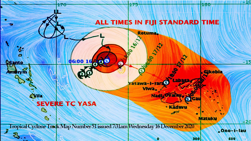
![Tropical Cyclone Warning Number 51 issued 7:31am Wednesday 16 December 2020 [Photo: met.gov.fj]](https://www.fijivillage.com/news_images/16560940005fd9207371be2113cec8.jpg)
Tropical Cyclone Yasa has rapidly intensified and is now a category 5 system as it heads towards us.
A Tropical Cyclone Alert remains in force for Yasawa and Mamanuca Group, Northern half of Viti Levu (from Nadi through to Korovou), Northern half of Vanua Levu (from Nabouwalu through to Votua to Labasa through to Udu Point), Lomaiviti and Rotuma.
The cyclone alert will be in force for the rest of the group from today.
A Heavy Rain Warning is now in force for the Yasawa and Mamanuca Group, eastern half of Viti Levu, Vanua Levu, Taveuni and nearby smaller islands.
A Heavy Rain Alert is now in force for the rest of the Fiji Group.
A Flash Flood Alert remains in force for the low lying areas and areas adjacent to small streams for the interior of the main island; upper Nadarivatu, Monasavu, upper Wainimala, upper Sigatoka and upper Nadi area.
People need to take all the necessary precautionary measures as the Nadi Weather Office has analyzed that Cyclone Yasa will come right over Fiji as a very intense category 5 cyclone from tomorrow.
The Weather Office says Cyclone Yasa is located about 520 Kilometres West North West of Yasawa I rara .
Yasa is currently moving North East towards us at 8 kilometres per hour.
Forecasters say the effects will start from later today.
Continuous heavy rain is expected to result in flooding in parts of Fiji.
Strong to gale force winds will also start over Yasawa and Mamanuca from tonight.
Cyclone Yasa is expected to remain slow moving for the next 12 hours and remain over open waters.
From midday today, Yasa is expected to pick up speed as it tracks towards us.
Acting Director of the Nadi Weather Office, Terry Atalifo says Cyclone Yasa will maintain it’s intensity and is expected to become a category 5 with hurricane winds by the time the centre of the system lies over Yasawa and Mamanuca.
People living in Viti Levu, Vanua Levu and other islands in the Fiji group can expect damaging to destructive winds from tomorrow.
Atalifo says Cyclone Yasa is a large system which has a distance of 400 kilometres from end to end. Please note that damaging to destructive winds, storm surges and heavy rain will affect areas hours before and after the centre of the cyclone passes.
/+AUDIO-11368712725fd83ed60dd339228d25.mp3+AUDIO/
Yasa’s centre is expected to go between Viti Levu and Vanua Levu from tomorrow to Friday, which means people can expect damaging to destructive winds, gusting to 230 kilometres per hour.
Atalifo says people in heavily populated areas like Suva to the Nausori corridor can expect damaging winds and heavy rain tomorrow and destructive to very destructive winds on Friday.
Cyclone Yasa may cause widespread power failure, blow away roofs and cause considerable damage to structures especially weak-structured houses and even cause damage to well-built houses.
Damaging winds can also uproot big trees and cause total damage to shallow-rooted plants and crops.
Due to anticipated widespread heavy rain, there is risk of river flooding and flash flooding of low lying and flood-prone areas.
From today we can expect high waves more than 6 metres over southwest Viti Levu waters, Yasawa and Mamanuca waters and Kadavu Passage.
Areas that can get affected by coastal flooding are Northern Vanua Levu (from Bua to Labasa onto Udu Point), Northern Viti Levu (from Sigatoka, Nadi, Lautoka to Ba, Rakiraki onto Tailevu) Mamanuca and Yasawa.
Avoid going out to sea as there are already high waves out in the open waters.
Meanwhile, Tropical Cyclone Zazu is currently over Tonga and is expected to drift southeastwards away from Tonga and poses no direct threat to the Fiji Group.
Please be prepared for the impending cyclone. Secure your homes, ensure that you or your neighbours do not have loose material that can fly around and cause damage during the devastating winds.
Have your supplies ready, have some standby food and water, ensure you have a transistor radio and batteries to follow the weather reports on Fijivillage and ensure you have emergency lights and torches.
Stay with us for developments.
Related stories;