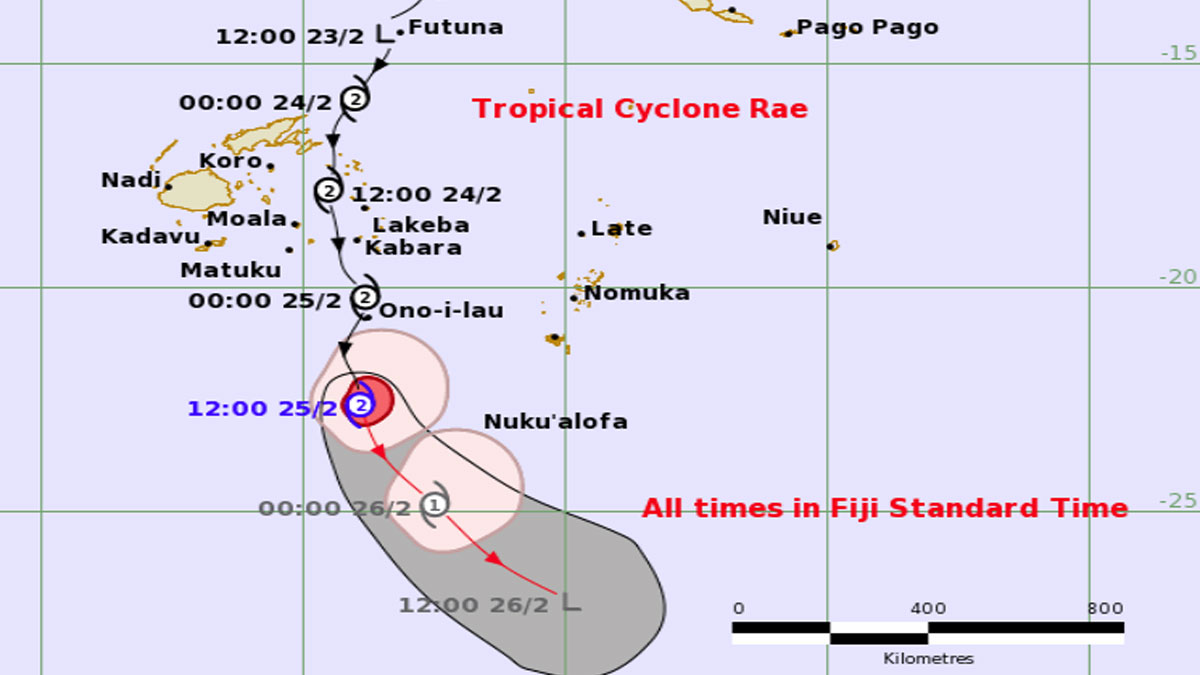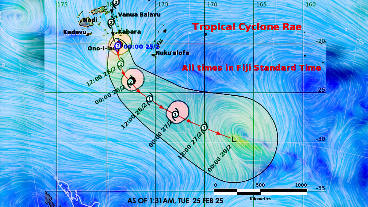
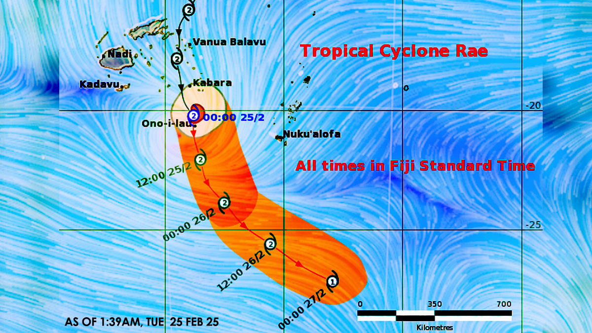
Tropical Cyclone Rae is expected to slowly weaken while tracking South-southeast away from the Southern Lau Group later today.
The Nadi Weather Office says the centre of Cyclone Rae is located about 10km North-northeast of Ono-i-Lau or about 185km South of Kabara.
TC Rae is moving South-southeast at about 20 kilometres per hour over the Southern Lau Group.
A storm warning remains in force for Vatoa and Ono-i-Lau while a gale warning remains for Lakeba, Oneata, Moce, Komo, Namuka-i-Lau, Kabara, Fulaga, Ogea and Totoya.
Meanwhile, an active convergence zone with associated strong to gale force winds will affect the Northern and Eastern parts of the group.
For Vatoa and Ono-i-Lau:
Expect gale to storm force winds with wind speeds from 65km/hr to 110km/hr and gusts from 90km/hr to 155km/hr.
Winds gradually easing to strong to gale with wind speeds up to 75km/hr and gusts up to 100km/hr this morning.
For Lakeba, Oneata, Moce, Komo, Namuka-i-Lau, Kabara, Fulaga, Ogea and Totoya: Expect strong to gale force winds with wind speeds from 45km/hr to 85km/hr and gusts from 80km/hr to 120km/hr.
A gale warning remains in force for the Eastern parts of Vanua Levu [Cakaudrove province, Eastern Macuata and Southern Bua], Cikobia, Naqelelevu, Taveuni, Koro, Ovalau and Ono-i-Lau.
Expect strong to gale force winds with wind speeds from 45km/hr to 85km/hr and gusts from 80km/hr to 120km/hr.
A strong wind warning remains in force for the rest of Vanua Levu, Northeastern parts of Viti Levu from Tailevu North through Ra-Rakiraki up to Tavua, Yasawa, Mamanuca, Kadavu and nearby smaller islands.
For the Eastern and Northern parts of Viti Levu from Sigatoka through Suva to Tailevu North up to Rakiraki/Tavua, Yasawa, Mamanuca, Kadavu and nearby smaller islands: expect fresh to strong southeasterly wind speeds up to 55km/hr and gusts up to 80km/hr.
A heavy rain warning remains in force for the whole of Fiji group.
A flash flood warning is in force for all small streams and low lying flash flood prone areas of Viti Levu and Vanua Levu.
Possible impacts expected from the tropical cyclone:
- significant structural damage to houses of unshielded and very light structures in exposed communities.
- possible disruption in communication network and power supply due to damaged power lines.
- trees/plants and crops damaged and downed.
- high risk of sea travel for all types of sea crafts.
Possible impacts due to heavy rain:
- localised flooding of susceptible communities, business and low lying areas.
- localised flooding of minor roads, Irish crossings and bridges with some disruption to traffic flow.
- severe flooding of major rivers which could flood towns and properties.
- poor visibility for drivers and mariners.