![Satellite image at 11am, 29th December 2018 [Photo: http://www.met.gov.fj]](https://www.fijivillage.com/news_images/19375967715c26feb78abb6aaaaec6.jpg)
A flood warning is now in force for low lying areas near the Naqali river.
The Weather Office says the water level at the Naqali river was 3.91 metres which is 0.4 metres above warning level and increasing.
There is also a flood alert in force for low lying areas next to major rivers in Vanua Levu and along the Rewa catchment area near the Rewa river.
A heavy rain warning is now in force for Vanua Levu, Taveuni and nearby smaller islands, Lau and Lomaiviti Group and Eastern Viti Levu.
The Eastern parts of Viti Levu includes areas along the Coral Coast, Nausori and Tailevu.
Heavy rain is already being experienced in Nausori and Korovou.
This rain is being brought by two separate low pressure systems.
The Weather Office says a trough of low pressure lies over the southern parts of the Fiji group while another trough of low pressure with associated cloud and showers affects the Fiji group from the north.
It says localised heavy falls may lead to flash flooding of low lying areas.
The low pressure system is anticipated to intensify further into a depression in the next few days as it moves southeast towards the group.
Earlier story: Severe weather conditions predicted in the coming days
The weather activity has picked up and anticipated to further enhance from tomorrow as a trough of low pressure with associated cloud and showers is expected to affect the Group from the weekend.
Acting Director of Meteorology Viliame Vereivalu says showers are anticipated to become frequent and heavy over most places from tomorrow.
A strong wind warning remains in force for Vatu‑I‑Ra and Kadavu passages.
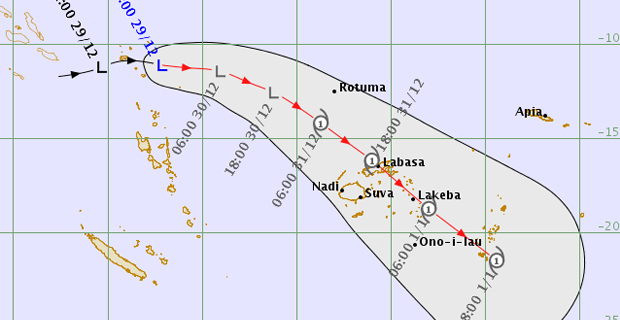
Meanwhile, a low pressure system lies slow moving near Solomon Islands and this low pressure system is anticipated to intensify further into a depression in the next few days as it moves southeast towards the Group.
Vereivalu says it is expected to affect Fiji and Rotuma from Monday.
He says as the system moves closer to the Group, it is expected to bring rain, heavy at times and moderate to fresh southeast winds over lands areas from Sunday.
People can expect strong winds with speeds of 45 to 55 km/hr from Monday which is expected to enhance to gale force winds, with speeds of 60‑75 km/hr gusting to 100km/hr from Tuesday.
Winds can break tree branches and uproot shallow rooted trees as it picks up speed.
There is a high risk of flash flooding and flooding of low lying areas from Monday.
People living in flood prone and landslide areas are requested to remain alert in the next few days as severe weather conditions are predicted in the coming days.